Informed Decisions Driven by High-Precision Data
As Reidsville continues to grow as a vital hub for industry and infrastructure in Tattnall County, the requirement for pinpoint accuracy in geospatial data has never been higher. For project managers, civil engineers, and environmental consultants throughout the Coastal Plain, traditional ground-based surveying often fails to meet the aggressive timelines of modern development. Fair Lifts Survey & Mapping Services offers a revolutionary approach to data collection. We don't just capture "aerial views"; we deliver a comprehensive geospatial "foundation of truth" that informs your most critical project milestones.
Our methodology is designed to solve the most persistent challenges in regional surveying: high operational costs, safety hazards on active industrial sites, and the slow turnaround of manned aircraft. Utilizing a fleet of Department of Defense-vetted Blue UAS platforms equipped with top-tier sensors, we can map thousands of acres and millions of data points in a single day. Whether you are managing an aggregate operation in Reidsville or overseeing a sprawling utility corridor across the county, we provide actionable datasets that integrate directly into your existing GIS and CAD ecosystems.
The Security of Blue UAS Certification
In the current security landscape, protecting your site’s digital integrity is a top priority. Every Fair Lifts survey system is Blue UAS Certified, having undergone exhaustive cybersecurity and supply chain vetting by the U.S. Military. For those managing critical infrastructure near Reidsville—including power generation and transit pipelines—this certification guarantees that your sensitive asset data remains secure from the moment of capture to final delivery, eliminating the vulnerabilities found in unvetted drone hardware.
Precision Volumetrics: Mastering Inventory Management
For the industrial and mining sectors of Tattnall County, maintaining an exact count of inventory "to the last ton" is essential for financial transparency and operational flow. Sending personnel to manually walk steep stockpiles or navigate active highwalls is not only time-consuming but a significant safety liability. Fair Lifts mitigates these risks while simultaneously increasing the precision of your measurements. Our 61MP sensors capture high-resolution data to build dense 3D reconstructions of your entire facility.
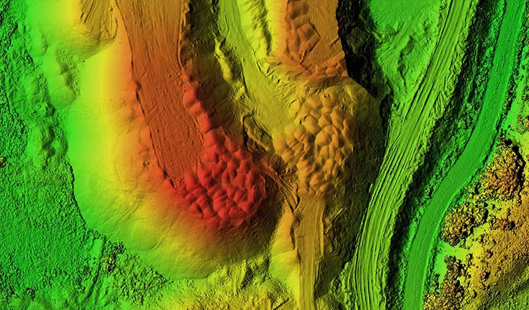
We process this information via PIX4Dmatic, the gold standard for large-scale volumetric calculation. This allows us to generate auditable stockpile volumes and cut/fill reports with centimeter-level precision. For accounting departments in Reidsville, this means the stress of monthly reconciliation is replaced by a transparent, measurable record of assets. We provide a shareable, digital version of your site that can be analyzed by your team within 24 hours of our flight, turning raw material into a fully quantifiable asset.
LiDAR Mapping: Seeing Through the Coastal Plain Canopy
The South Georgia Coastal Plain is defined by its thick pine stands and dense hardwood canopies, which typically render standard aerial photography useless for ground-level mapping. Engineering projects in Tattnall County require a precise understanding of the terrain hidden beneath the trees, particularly for drainage and site preparation. Fair Lifts’ LiDAR (Light Detection and Ranging) services provide the definitive solution. We utilize the Riegl miniVUX-2UAV, a sensor engineered for the highest possible vertical precision.
LiDAR functions by emitting millions of laser pulses every second. These pulses are capable of filtering through the thickest vegetation, reflecting off the soil to create a "bare earth" Digital Terrain Model (DTM). For Reidsville developers preparing new commercial sites or engineers calculating water runoff, this data is indispensable. Our LiDAR surveys achieve better than 1-inch absolute vertical accuracy and a point density of up to 800 points per square foot, uncovering topographical details that other methods simply cannot detect.
Expansive Infrastructure Surveys & Multi-Fleet Deployment
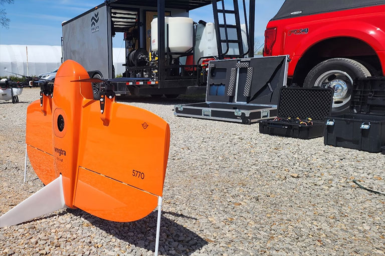
The sheer size of regional infrastructure projects often creates a bottleneck for traditional data collection. Standard drones lack the flight time to cover vast areas, and manned planes are often too costly for routine updates. Fair Lifts employs the WingtraOne Gen II, a fixed-wing VTOL (Vertical Take-Off and Landing) aircraft capable of mapping over 700 acres per flight—ten times the capacity of a standard quadcopter. For major Reidsville developments, such as industrial parks or massive timber tracts, we can deploy multiple crews and aircraft simultaneously.
This synchronized data acquisition allows us to survey thousands of acres in a single day without any loss in data quality. Our integrated Post-Processed Kinematic (PPK) systems ensure every data point is geotagged with centimeter-level precision, drastically reducing the need for manual ground control points. This accelerates your project timeline and minimizes our physical footprint on your site, delivering a massive, unified dataset ready for immediate land development planning or GIS analysis.
3D Digital Twins & Property Visualization
Evolution your project perspective from flat maps to photorealistic 3D digital twins. Traditional 2D blueprints often fail to convey the true spatial relationship of complex infrastructure. Fair Lifts produces immersive, measurable 3D property models that allow Reidsville stakeholders to visualize, analyze, and present projects with unparalleled clarity.
By blending top-down imagery with oblique angles, we generate textured 3D meshes and point clouds that provide a permanent "as-built" record. This is a transformative tool for monitoring construction progress, conducting shadow studies for architectural design, or marketing premium commercial real estate in Tattnall County. For local developers, a digital twin offers a verifiable history of earthwork and structural placement, ensuring the build remains perfectly aligned with the design specs throughout its lifecycle.
Technical Accuracy Metrics
Horizontal Accuracy
1.0 cm
Full PPK Integration
Vertical Accuracy
< 2.5 cm
High-Density LiDAR
Ground Sampling Distance (GSD)
0.7 cm/px
61MP Full-Frame Sensor
Comprehensive Project Management
Your dedicated Tattnall County Project Manager handles the entire lifecycle of your data, from initial site scoping and sensor optimization to final delivery in Pix4Dmatic. We provide data in the exact formats your engineers require: DXF, DWG, LAS, and GeoTIFF.
Request Technical Consultation